


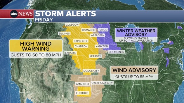
(NEW YORK) — Millions of people in the High Plains will experience widespread wind gusts between 60 and 80 mph, from Montana to Kansas.
This wind, which will last all day and into the evening, could take down large trees, cause power outages, reduce visibility with blowing dust, and make travel dangerous for high-profile vehicles, which could be turned over.
On the eastern side of the strongest winds, blowing snow is also expected — either snow that has already fallen and is picked up from the ground, or new snow from the new storm.
A winter weather advisory is in place from North Dakota to Iowa for gusts between 40 and 50 mph, with snow accumulations up to one inch.
Light snow is forecast to fall across Wisconsin and Michigan, continuing into Michigan and Ohio on Friday afternoon.
In the evening, snow is forecast to fall from West Virginia and Ohio to western Pennsylvania and western New York. On Saturday, snow is possible across much of the Northeast.
The I-95 corridor may see snow Saturday morning and early afternoon, or a rain and snow mix, from Washington, D.C., to Maine.
A dusting is possible in Washington, D.C., around an inch is expected in Philadelphia and up to 2 inches are possible around New York City and Boston.
Farther inland, parts of upstate New York, western Connecticut and western Massachusetts, and parts of areas north of I-90, may see 3 to 6 inches of snow accumulation.
Snow will be out of the region by late afternoon Saturday.
Copyright © 2026, ABC Audio. All rights reserved.


